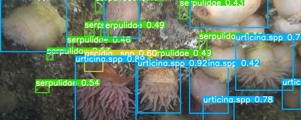
The state of the marine environment is assessed, among other things, through inventories and monitoring programmes of various kinds. For example, it can be through filming or photographing the seabed in an area, and then looking at the images to identify which species are there. A job that takes a lot of time.
The new digital tool SUBSIM uses machine learning for species identification instead. Images and videos are uploaded to a server and out comes species lists, amounts of biomass, maps with coverage for eelgrass, for example, or something else that the analysis has been tailored for.
"We hope that SUBSIM will become a national platform for monitoring and understanding the marine environment better. We have now created a first system that can be adapted and further developed depending on the needs of different users," says Matthias Obst.
Mapping mussel banks in the Baltic Sea
A partner in the development of SUBSIM is the Geological Survey of Sweden (SGU). Here, the tool has been adapted to assist in the mapping of various bottom environments in the Baltic Sea, such as mussel banks. The mapping is based on high-resolution images photographed with a camera that is lowered to the seabed. So far, bottom types have been identified manually in a number of randomly selected points in the images.
"Using SUBSIM, the reading is faster and information from the entire image can be analysed instead of in a few points. In this way, it will be possible to obtain very high-resolution maps of the seabed in the future," says Matthias Obst
Can follow size development of fish communities
The tool can also be used to identify mobile organisms. In a collaboration with a wind power company, SUBSIM's algorithms are trained to determine the species and measure the size of fish, completely automatically. The aim is to be able to monitor what is happening around offshore wind farms.
"For example, you want to be able to follow whether there are more or fewer species, or if the size composition of the fish community changes", says Matthias Obst.
The inventories that form the basis for environmental monitoring in the sea are often carried out with divers or with remotely operated underwater vehicles controlled from boats. In the future, surveillance work will be largely automated, Matthias Obst believes.
"You can imagine underwater drones patrolling over the seabed and filming and analysing the images on site. They can also be programmed to let you know if they notice anything out of the ordinary or odd. Within ten years, it will be technically possible."
Opens up for large-scale environmental monitoring
SUBSIM is based on the development of machine learning models, which are tested and trained to recognize marine species, but also non-biological structures such as cavities for Norwegian lobster, or trawl tracks on the seabed. The user uploads their images or videos to a server, and if the "right" algorithms have already been trained, the image material can be analyzed immediately. If not, the process begins with learning and training the model to recognize what you want to investigate. Matthias Obst believes that there is great potential for large-scale monitoring of entire marine areas in the future, but that we still have some way to go.
"SUBSIM is a good start. We are now opening up the system to be able to develop it further together with interested users at authorities and companies. Machines can never replace biologists and ecologists, but they can make their work more efficient and increase our abilities to understand changes in the ocean."
Text: Susanne Liljenström


